Curious Kids: how and when did Mount Everest become the tallest mountain? And will it remain so?
Most people know that Mount Everest is the tallest mountain but I want to know for how long it has been the tallest, and for how long in the future it will remain so (…) Which range preceded it? (…) When will something else overtake it? — Nigel, age 14, Christchurch
Nigel, thank you for this wonderful and insightful question. The answer is actually quite complex, since the height (or elevation) of mountain ranges in the past can be difficult to know.
However, it is a very important question as mountains have a huge role in the environment. They can disturb air flow, affect global and regional climate and provide opportunities for plants and animals to evolve.
Understanding the history of mountain ranges
Geoscientists address questions about ancient mountain heights by looking at sedimentary basins within mountain ranges. These are low areas where sediment materials such as pollen and plant leaves collect and minerals form in the soil.
A basin today may be much higher or lower than it was when sediment entered it. The fossilised pollen, leaves and minerals that date back to the time when the sediment was deposited can reveal how the landscape’s elevation changed over time.
If we look at fossilised pollen, we may find it comes from plants which likely grew in a particular range of elevation, and we may also notice the absence of certain other plants. (We can figure out where ancient plants likely grew by looking at their modern relatives.)
So by dating the pollen we find, we can calculate the landscape’s possible range of elevation in the past. We can conclude the landscape was too high for plant A, high enough for plant B (which gave us the pollen), but not high enough for plant C.
That is a pretty powerful capability, especially if the elevation of the landscape has changed significantly since the sediment was first deposited.

We can also look at the different kinds (or isotopes) of certain elements (particularly oxygen) contained in plant waxes, clays and carbonate minerals that form by chemical reactions in the soil. These plants and minerals incorporate rainwater.
As a band of rain reaches a mountain range, water with heavier oxygen isotopes falls out first. This means rainwater at higher elevations contains lighter oxygen isotopes, which then pass into the plants and minerals there.
If we find sediment that was deposited into a low basin 30 million years ago, but is now much higher, it will still contain oxygen isotopes that reveal the elevation at which it first formed. We can measure these isotopes to estimate how much higher the landscape has become.
How long has Everest been the tallest?
Everest is part of the Himalayas, a mountain range that stands at the southern edge of the vast Tibetan Plateau which is around 4-5km above sea level. Scientists have used the methods described above to understand the history of the plateau, which evolved as a result of several ancestral mountain ranges joining up.
Parts of the modern plateau were already higher than 3.5km by 26 million years ago. The southernmost of those ranges was a great, Andes-like mountain range called the Gangdese mountains.
These seem to have existed for more than 50 million years at elevations similar to those of the Andes today (about 4.5km).
However, south of the Gangdese, where we have today’s highest mountains, geologists found 34.5-million-year-old sediments from a shallow sea only a few dozen kilometres east of Mount Everest (locally called Qomolangma).
This tells us the part of the Himalayas that includes Everest, which now dominates the skyline, was not a mountain range back then. In fact, it was at sea level. It has grown more than 8km in the last 30 million years.
Everest, now the big kid on the block, is currently more than 100 metres higher than its closest rival. But a new victor will emerge with time.
What happens next?
To understand how Everest might lose its highest mountain status, we need to understand how mountain ranges are built. The largest mountain belts today were built from collisions between blocks of continental crust in Earth’s outer layer, the lithosphere.
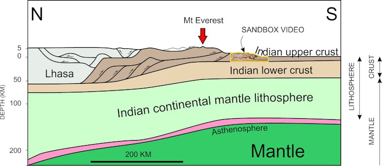
As these blocks collide, they crumple and slices of rocky crust get stacked on one another, as seen in the right half of the cross section below. This gives birth to high mountains, which continuously rise and shift and change as the collision continues.

The video below helps visualise this process. It simulates the squeezing of a block of lithosphere in the Himalayas. You can refer to the “Sandbox Video” part of the cross section above to see where this process would occur.
You’ll notice the mountains begin to rise as soon as the collision begins. The arm pushing the sand represents the already thickened crust of the high Himalayas and the sand pile being pushed represents the Indian upper crust which lies below the mountain range.
The thickening moves to different spots over time. While the youngest and smallest mountain is furthest from the collision itself, the highest peak isn’t always in the oldest part of the range (where the collision began).
Eroding and growing
Large mountain ranges “erode” when changes in temperature, wind and water break down the rock and ultimately carry it away. Interestingly, erosion actually causes mountains to slowly grow over time.
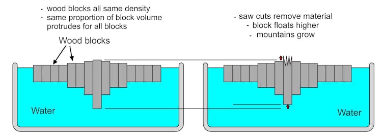
This is a fascinating process geoscientists call “isostasy” which can be measured using GPS. The diagram below shows how the process is comparable to blocks of wood floating in water.
If intact blocks of a certain type of wood float in a pool, the same percentage of the overall volume will always protrude above the surface. So, if material is removed from one block, that block will rise.

We can compare these columns of wood to lithospheric blocks. As more erosion occurs, the mountain’s surface increases in elevation. This gives a way for deeply buried rocks to rise within the mountain range.
Hard to beat
Despite having 82,350km of convergent boundaries on Earth (where two plates meet and push together), it’s unlikely other mountain ranges will surpass the height of the Himalayas anytime soon.
This is because the Himalayas were built by the collision of two large continents composed of rocks with lower than average density. They therefore sit higher than the oceanic lithosphere.
One day in the distant future a new boundary will form somewhere and the forces creating the Himalayas will be removed.
The range will then collapse and eventually erode to become like the modern-day Appalachians in North America, which was an active mountain belt from between 325 and 260 million years ago.
Read more: Curious Kids: how do mountains form?
Hello, curious kids! Have you got a question you’d like an expert to answer? Ask an adult to send your question to us. You can:
* Email your question to curiouskids@theconversation.edu.au
* Tell us on Twitter by tagging @ConversationEDU with the hashtag #curiouskids, or
* Tell us on Facebook

Please tell us your name, age and which city you live in. You can send an audio recording of your question too, if you want. Send as many questions as you like! We won’t be able to answer every question but we will do our best.


